22 February, 2016

Homeward Bound...


And so, our time on Rapa Nui has come to an end. In fact, so has this entire trip, to Chile, the southern tip of Argentina, the Antractic Pensinsula, the Orkneys, South Georgia and the Falklands too. Experientially, this must have been our best ever holiday. Nowhere else have we been so astounded, and seen so much that is new.
This map, by Eric Gaba (see citation below), had red spots to show the sites we visited. It also shows the approximate location of our Explora Hotel.

Fruit in the bowl at Explora.

Rapa Nui wildflowers.


Getting back to Rapa Nui, our fabulous guide, Ata, dwelled on the past, as he was probably paid and expected to do, and didn't show us much of the current Rapa Nui. In retrospect, we should probably have spent another day on Rapa Nui - the Explora Hotel was certainly pleasant enough! - so we could walk around the town of Hanga Roa and visit the marina, to see what present day Rapa Nui is like, and also to relax a bit and better enjoy the hotel facilities!
Cooling off in the Explora infinity pool, after a hot day on the road with Ata.


Is there anywhere else in the world that is more remote than Rapa Nui, or whose history is so interesting but shrouded in mystery? For these reason alone, this little volcanic island is worth a visit. We are very pleased to understabd that the restoration projects undertaken by William Mulloy and Claudio Cristino and others from 1955 have reawakened the Rapa Nui population's self-esteem and pride in their vital contribution to Polynesian history, and, apparently, transformed the island and its place in the world.

This reinvention seems to have led to the annual Tapati Festival, organised "by locals for locals", as a celebration of Rapa Nui's past. We just missed this Festival - it was held from 29Jan - 14Feb 2016, finishing barely a day or two before our arrival. The Festival, which would be wonderful to see, consists of a variety of locally relevant traditional events such as Haka Pei, where contestants slide down a steep hill at treacherous speeds, 80km/hr, on banana trunks. There is horse racing (apparently the gaucho style of riding from South America is popular), a triathlon (run, swim, canoe), and dance competitions. For Tapati, the populace splits into two clans representing the divisions of the original Polynesian arrivals. Fortunately, the destructive competition between clans of the past is replaced by peaceful endeavours which must, for Rapa Nui, be akin to nation building.
Two posters seen at the Explora. The '94 poster may be a reference to a movie that year. The other poster is for the annual Tapati cultural festival, organised "by locals for locals".

Promotional material for the 2016 Tapati Festival. Bare feet - it looks like a tough event.


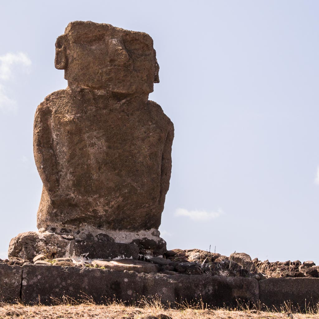
And our visit causes us to reflect on the anthropogenic environmental disaster that caused Rapa Nui society to fail in the mid 1700's. Irrational competition to produce ever-larger mo'ai so diminished resources on Rapa Nui destroyed tree species to the extent that the natives could not build canoes for fishing. The absence of trees degraded the topsoil and farming failed. The island could not sustain itself. Overpopulation was the result and led to isurrection and clan wars, mo'ai were toppled in huri mo'ai, and the population was reduced to a fraction. Is this behaviour any different to what is happening in our society today, where city developers seem to prevail over saner heads seeking less growth and sustainable solutions? Where never-ending growth is the target regardless of a finite planet? Where money rules over science? What have we learned? Are we any better?
View over Hanga Roa and Mataveri airport. The airport was improved by NASA so it could be available for possible Pacific rescue missions from its space program.

Getting the windows cleaned at our Santiago hotel on our last day in Chile.


Back to Santiago, then the Qantas QF28 flight home presumably followed a Great Circle from Santiago (SCL) to Sydney (SYD) to minimise the distance flown. This route sent us way down south towards Antarctica, and south of New Zealand, as confirmed by the Flight Map on the plane's entertainment system when viewed at various times. We never saw Antarctica from the window because, apart from trying to sleep, we were probably a bit too far north and it was very cloudy anyway.
Spectacular view of Chilean volcano from QF28 as we headed south on the great circle route to Sydney.

The great circle route from Santiago to Sydney goes well south!


Rapa Nui map By Eric Gaba (Sting), translated by Bamse - Own work. Shorelines, ponds, roads, trails and airport drawn using Landsat 7 ETM+ imagery (public domain);Topography: NASA Shuttle Radar Topography Mission (SRTM3v2) (public domain);Main references used for the toponymy:prof. William Mulloy's map (easier to read here);Pacific Island Travel map (http://www.pacificislandtravel.com/easter_island/about_destin/isla_de_pascua[1].jpg);[1], CC BY-SA 2.5, https://commons.wikimedia.org/w/index.php?curid=2940588

21 February, 2016

Towards Birdman...


Rapa Nui now has a population of 6-7,000 (and 10,000 horses!), but in days gone by it was 15,000 or more, depending on which expert you ask. Apparently, the overpopulation and the resources required to sustain the obsession of bigger and bigger moai caused extreme deforestation and a massive breakdown in society in the 1700's, during which the population dropped to maybe 2-3,000 and the moai were toppled and vandalised. The situation got worse in the 1800's when Peruvian slave traders captured half the population and introduced smallpox etc.

In setting a schedule for our extended tour of Rapa Nui, Ata proved himself to be a showman - under the guise of guiding us through the various phases of island history and mythology, from the Polynesian arrival, through the irrational ma'oi years and then the crisis which followed, and finally the birdman era, he artfully saved the best for last! Our last day on Rapa Nui was eye-popping, and answered many questions.

Tongariki

Ata drove us to the eastern end of Rapa Nui, to a spot somewhere between two volcanic caldera, called Tongariki. The ahu here is stunning, the biggest on the island, with 15 restored mo'ai side by side. The mo'ai have their backs turned to the coast and face sunset on the summer solstice.

Only one of the 15 mo'ai sport a pukao on its head, but there are a number of pukao lying on the ground nearby. We don't know why the restoration team left them on the ground - may have been engineering problems, or maybe they didn't know which hat belonged to which statue.

This site has undergone even more disruption than most on Rapa Nui. Apart from the general destruction of huri mo'ai, the toppling of all the mo'ai, around 1800, Tongariki's ruins were further scattered by the tsunami following the Valdivia (Chile) earthquake in 1960.

But then, Tongariki's restoration in the 1990's leading up to the spectacular sight we see today, was led by none other than Ata's father, Claudio Cristino from the University of Chile.
In the caldera of Volcano Rano Raraku.

Tongariki is halfway between two volcanoes, Rano Raraku and Poike.

The incredible 15 ma'oi of Ahu Tongariki, behind the solitary "Wallking Mo'ai" which was possibly abandoned whilst en route to its ahu.

Count them! All 15 mo'ai of Ahu Tongariki.

The only mo'ai of Ahu Tongariki to have a scoria pukao on top.

Leaden skies as Ata tells us of the 1960 tsunami which demolished the ruins of Ahu Tongariki.

Viewed from Poike, the 15 mo'ai of Ahu Tongariki.

From the south east, the back view of these 15 mo'ai.

At the base of the ahu, Glenn shows us the sacle of these giant mo'ai.

These must be the pukao from the Ahu Tongariki mo'ai.

From any angle, the mo'ai of Ahu Tongariki are an amazing sight.

Ahu Tongariki plus a row of disconnected pukao.

This view begs the question - how did they get those pukao into position?

The six of us on this Lindblad Rapa Nui tour, Dick, Clare, Mike, Glenn, Bob and Helene.

From here came the tsunami. View of Ahu Tongariki from the slopes of Rano Raraku.


Rano Raruku

The secrets of mo'ai construction were revealed to us only 5 minutes drive from Tongariki, at Rano Raraku. This volcano is the quarry for tuff, the volcanic ash used to make most mo'ai. Here, we could see new mo'ai being carved directly from the exposed tuff in the ground, after which they were slid downhill and uprighted on a journey to their intended ahu. Many partly completed and relocated mo'ai are found abandoned on these slopes - they were not subjected to the toppling, and have remained upright.

Rather supporting the hypothesis that some determined competition between clans required progressively bigger and bigger mo'ai, the largest ever mo'ai are found partly completed but then abandoned at Rano Raruku. One is 21.6m tall, about 270t, twice the size of any other mo'ai.
The slopes of Rano Raraku, half buried, incomplete mo'ai, abandoned during the crisis.

Rano Raraku finally explains to visitors how the mo'ai were constructed.

One of many mo'ai on the slopes of Rano Raruku.

Tukuturi, the only bearded and kneeling mo'ai at the tuff quarry, but made of scoria! Another Rapa Nui mystery.

Stunning, huge, partly carved mo'ai, abandoned in mid-construction.

Ata, demonstrating the tools used to carve mo'ai.

Some Rano Raruku mo'ai appear to have been abandoned because carving became too difficult.


Anakena

On the north shore of Rapa Nui is Anakena, one of only two sandy beaches on the rocky coasted island. It is probably the site of the earliest human settlemment on Rapa Nui, possibly as early as 300CE, but could be as late as 800CE. By tradition, Hotu Matu'a arrived in two canoes from (probably) the Marquesas, and became the ancestor of all Rapa Nui people. Being a beach, it probably made for an easy landing.

Hotu Matu'a picked a nice spot. The beach is beautiful (and popular), the water delightful, but it was frightfully windy on our visit. It reinforced our prior jocular remark that the real meaning of Rapa Nui is place of incessant winds! We read that Anakena was one location used in the 1994 film "Rapa Nui".

Before Ata allowed us to have a swim, he showed us the ahu here with seven restored mo'ai (1978) on Ahu Nau Nau, and the solitary Ahu Ature. Some of the detail in petroglyphs is better preserved here than in other locations, possibly because the mo'ai were buried in protective sand.
Clear petroglyphics on the backs of the mo'ai and the ahu platform.

The broad and solitary mo'ai at Ahu Ature.

The only mo'ai that you're actually allowed to touch!

Four of the mo'ai at Ahu Nau Nau have their pukao on.

These mo'ai have their backs to a stunning view of the Anakena beach.

Surfing at the windswept beach of Anakena.

A volcanic lava cave as seen from the water at Anakena.


Vinapu

Almost in the shadow of the built up end of the airport runway is Vinapu, a large but unrestored site of fallen mo'ai and precise basalt stonemasonry which is (to archaeologists) evidence of Peruvian Inca influence (or is it vice versa?). The site dates around 1440.
The precise assembly of basalt blocks here is unique.

Ata's van parked nearby at Vinapu.


Orongo and Rano Kau

The Rano Kau volcano, and on the edge of its caldera, the historical valliage of Orongo, lie on the south western tip of Rap Nui. Here we learn (a) where the island's water comes from and (b) something of Rapa Nui's fascinating birdman cult which followed the crisis of mo'ai toppling.

Orongo is a restored (1974) ceremonial stone village of sod-covered, windowless, almost doorless, circular buildings. These were used by clan appointed warriors (the birdmen) and priests preparing for a very dangerous annual race (1700's) to bring the first manutara (sooty tern) egg back intact from the nearby islet of Motu Nui.

The descent from Orongo to the water is a terrifying cliff, and Ata suggested that warriors died going this way, and that the more successful took a longer and more gentle route, followed by a much longer swim. The winning warrior earned special privileges for himself and his clan. Whether this competition replaced the environmental distaster of mo'ai construction, or coexisted with it, is uncertain. Ata suggested that the winner's privileges were frustrated by devious priests anyway.

The whole birdman tradition was put to an end by Christian missionaries, horrified by naked pagan rituals, in the mid 1800's, and replaced it with slavery and disease. To add insult to injury, a huge mo'ai Hoa Hakananai'a at Orongo was stolen by the British in 1868. It's now lives in the British Museum where, at least, it will be very well protected.
View from Orongo of Motu Nui, with the smaller Motu Iti in front and the isolated sea stack of Motu Kau Kau in-between.

The restored village at Orongo where warriors and priests would reside during the annual birdman race.

Birdman petroglyph on the rim of Rano Kau.

Stream of visitors to Orongo and Rano Kau.

Drawing of Birdman Warrior, at the Orongo visitors centre.

All that remains of the Hoa Hakananai'a mo'ai from Orongo, an image in the visitor's centre.


From near Orongo, one can look into the amazing and beautiful caldera of Rano Kau. It's full of marshy water and is, apparently, Rapa Nui's main water supply. If so, it is a fragile source. Ata points out that the caldera rim is deteriorating and eventually it will fail and drain the water into the sea. There are other volcanic lakes, though.
The spectacular caldera of volcano Rano Kau.

How reliable is this as a fresh water source for Rapa Nui?

20 February, 2016

Understanding the Mo'ai...


Our hotel, as arranged by Lindblad, was the Explora Rapa Nui. We don't know where this ranks on the island, but it was an excellent eco-resort with fabulous food and great cocktails (the local Pisco Sour went down very well), a very comfortable room, and an infinity pool, a sauna and a wellness spa. Explora operates luxury hotels in remote destinations in South America. In our room was an Amelia Earhart quote, "Adventure is worthwhile in itself".
Beautiful rural outlook to the east from the Explora.

Spectacular afternoon at Explora Rapa Nui.


The whole "feel" of the Explora reminded us of the Great Southern Lodge on Kangaroo Island in South Australia. The Explora was well patronised, with many guests apart from ourselves, all of who seemed to spend their days in the hands of enthusiastic and friendly guides. While Ata focused on history and mythology with us, hiking was popular, and so was diving, amongst the other guests.

The weather on Rapa Nui is sunny and warm, 20-30C, especially when compared to where we have been, but Ata warned us to be ready for a little rain every day. He was right, and we did well to always have raincoats with us. The rain was never heavy though, and the fabulous shower in our bathroom at Explora gave us cause to wonder where does the water come from!

The big questions on Rapa Nui, are how and why did the Polynesians build such big idols. Other polynesians managed to satisfy themselves with more modest statuary, such as totems or tikis, quite small or up to man-sized. What happened here? Well, we are really none the wiser. Moai are symbols of authority and power and repositories of the spirit after death. Did the various clan leaders compete with each other to produce bigger and better moai to increase their mana, some mystical spiritual currency?

Puna Pau

Considerable engineering and skill must have been involved in carving a large moai, getting it from the source material, and erecting. Before Ata lets us into these secrets, he showed us Puna Pau, a volcanic crater and apparently the only source of red scoria or cinder used for the moai's hat or topknot, pukao. How did the competing clans ever cooperate sufficiently to share this resource?
One of many abandoned pukao at Puna Pau.

The scoria quarry at Puna Pau.

Apparent carving area for mo'ai topknots at Puna Pau.

More horses than people on Rapa Nui!


Ahu Akivi

In gentle foothills of the Terevaka volcano, there is an altar of seven erect moai known as Ahu Akivi, more or less the same size. This site, restored by Mulloy, is maybe 5km away from the west coast, but here the moai are facing the ocean, and exactly face sunset at the Spring Equinox. Astronomical positioning does not occur elsewhere on Rapa Nui. By all accounts, Ahu Akivi was first built as a platform associated with cremation in the 1500's, with the moai erected much later, in the next century.
The 7 mo'ai at Ahu Akivi face east and the coast.

Like most restored mo'ai, these were broken at the neck, and are without eyes.

Dogs appear to roam Rapa Nui freely, and always appear when we visit a site.


Ana Te Pahu

Near Akivi is Ana Te Pahu, a long volcanic lava tube formed by rock solidifying around flowing lava. Ata told us that such caves are common on Rapa Nui and were used as refuge and habitation. This cavern looked big enough to hold an entire clan, and there was a lot of evidence of rock wall construction for defence purposes et al. Gardens were grown at entrances.
A steady stream of visitors to Ana Te Pahu.

Guava growing near Ana Te Pahu.

Entrances to the cave are hidden in a depression. Ata helped us climb down.

The cave extends some 500m!

We sampled a fruit Ata called "haia". It was sweet and fragrant.

This view of Ana Te Pahu shows that there is not much ceiling to the cave.

These wildflowers grow in sunny spots in the cave.


Akahanga

We went to the south coast quite close to the Explora Hotel. Here, at Akanhanga, we saw unrestored sites of destroyed altars and moai of two clans whose villages were within easy sight of each other, maybe only 200m apart. The moai have all been pushed over, most broken, amd rocks are strewn everywhere. Ata said that the destruction was generally caused within clans, not between them - evidently the populace wre disgusted with the profligacy of their betters. We noticed that red scoria was used here as part of the altars, not just the pukao. Petroglyphs were evident.
From the ruins of one clan at Akahanga, the next clan is very close.

Pushed over mo'ai at Akahanga, with red scoria altar stones quite evident.

Petroglyphs must tell stories of the past.


Moai and their Ahu commemorate dead royalty, but are not burial places. More typically, the dead are cremated with the remains placed on "tables" to be cleaned up by birds. Here, we could see one of these tables.
Table used to protect storage areas, and to lay out the remains of the dead.


Another cave, much smaller than Ana Te Pahu, was nearby.
Modest refuge cave near Ana Te Pahu.

Small vegetable farming activities acn be seen over Rapa Nui.

Example of Rapa Nui's rustic gate and fence construction.

The road from Explora south to the coast.

Political activism is alive on Rapa Nui, but what the protestors want is uncertain.

Spectacular sunrise on Rapa Nui.